-

- Trade Leads
- Trade Services
- B2B Directories
- Trade Connections
- Misc
- Contact Us


A free import export trade leads B2B marketplace since 1996 for manufacturers, suppliers, exporters, importers, buyers, sellers, wholesalers, freight forwarders, shippers, trade shows, exhibits, and export management.
Hello visitor from USA - 64 visiting from 29 USA
  11 France
  10 Canada
  4 Belgium
  3 UK
3 UK  3 Germany
  1 Hong Kong
  1 Iran
  1 Portugal
  1 Czech Republic
Hello visitor from
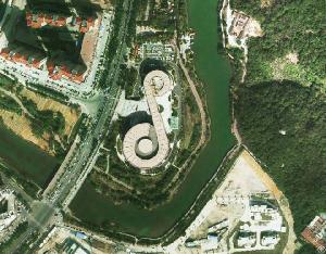
Feiyan Orthophoto
Posted at: Offers to Sell and Export | Posted on: Tuesday 16 August 2022 3:39 am | Poster last visit: Tuesday 16 August 2022 |
Product Category: Main
» Engineering and Research and Technology Based Services
» Earth science services
» Cartography
» Mapping
» Feiyan Orthophoto
Product Description:
Feiyan Technology specialises in high-resolution orthophoto map production including digital orthophotos
and orthophoto mosaics from raw aerial survey photography and digital image capture. Orthophotos combined with a topographic mapping project give a precise reference backdrop tool that enhances the users understanding of any project area. Combined into orthophoto mosaics the imagery can cover large areas such as a catchment, river basin, highway or even local government area.
Features & Benefits of Orthophoto
Orthophoto is an aerial photograph that has been geometrically corrected or ortho-rectified so that the scale of the photograph is uniform and utilised in the same manner as a map. An orthophotography can be used to measure true distances of features within the photograph. Planimetric corrections have been applied to remove lens distortions and optics, camera angle, and differences in elevation through a process of measuring ground control points to connect the photo to the ground, in a drawing-pin like manner. An orthophoto is an accurate representation of the Earth' s surface. Orthophoto has the benefits of high detail, timely coverage combined with the benefits of a map including uniform scale and true geometry.
Specifications of Orthophoto
Resolution: 0.1m
Project area: 4, 200km²
Duration: 90 days
Output: DOM(1:1000)
Application: The Third National Land Survey of Putian City
From: Putian City Land and Resources Bureau
Company Contact:

Contact Name: Frank Zhao
Company Name: Feiyan Aerial Remote Sensing Tech Co., Ltd.
Email:
Tel: 025-83216189
Fax: 025-83216189
Street Address: 450 S Taiping Rd
Siya Fortune Ctr, 8th Floor
Nanjing, Jiangsu 210008
China
Website: https://en.feiyantech.com/
Member name: feiyantech
Country: China
China
Member Since: 16 August 2022
Total Leads: 7 feiyantech Import Export Business Leads
Business focus: Aerial Photogrammetry, Lidar Data Acquisition, Dem, Orthophoto, Dsm Production
Chat:
Verify: Safe Import Export Tips
and orthophoto mosaics from raw aerial survey photography and digital image capture. Orthophotos combined with a topographic mapping project give a precise reference backdrop tool that enhances the users understanding of any project area. Combined into orthophoto mosaics the imagery can cover large areas such as a catchment, river basin, highway or even local government area.
Features & Benefits of Orthophoto
Orthophoto is an aerial photograph that has been geometrically corrected or ortho-rectified so that the scale of the photograph is uniform and utilised in the same manner as a map. An orthophotography can be used to measure true distances of features within the photograph. Planimetric corrections have been applied to remove lens distortions and optics, camera angle, and differences in elevation through a process of measuring ground control points to connect the photo to the ground, in a drawing-pin like manner. An orthophoto is an accurate representation of the Earth' s surface. Orthophoto has the benefits of high detail, timely coverage combined with the benefits of a map including uniform scale and true geometry.
Specifications of Orthophoto
Resolution: 0.1m
Project area: 4, 200km²
Duration: 90 days
Output: DOM(1:1000)
Application: The Third National Land Survey of Putian City
From: Putian City Land and Resources Bureau
Company Contact:
Contact Name: Frank Zhao
Company Name: Feiyan Aerial Remote Sensing Tech Co., Ltd.
Email:
Tel: 025-83216189
Fax: 025-83216189
Street Address: 450 S Taiping Rd
Siya Fortune Ctr, 8th Floor
Nanjing, Jiangsu 210008
China
Website: https://en.feiyantech.com/
Member name: feiyantech
Country:
Member Since: 16 August 2022
Total Leads: 7 feiyantech Import Export Business Leads
Business focus: Aerial Photogrammetry, Lidar Data Acquisition, Dem, Orthophoto, Dsm Production
Chat:
Verify: Safe Import Export Tips
 Mapping Classification Navigation
Main - Engineering and Research and Technology Based Services - Earth science services - Cartography - Mapping [6]
TradersCity.com shall not be held liable for any user posted/submitted content including but not limited to trade leads, profiles, images, and any other data. TradersCity.com does not and did not verify any of users posted/submitted data nor is implicitly or explicitly recommending these business offers. TradersCity does not verify truthfulness, accuracy, completeness, nor legality of any businesses, services, and leads posted here. TradersCity does not represent Sellers or Buyers in any transaction between users of the website and is unable to make any opinion in regard to their performance in any transaction. TradersCity neither guarantees nor undertakes in any dispute between sellers and buyers. Protect your business from fraud by trading safely